
File:1794 Jeffreys Map of Corsica, France - Geographicus - Corsica-jeffreys-1794.jpg

Size of this preview: 465 × 600 pixels. Other resolutions: 186 × 240 pixels | 372 × 480 pixels | 595 × 768 pixels | 794 × 1,024 pixels | 1,587 × 2,048 pixels | 3,000 × 3,870 pixels.
Original file (3,000 × 3,870 pixels, file size: 3.17 MB, MIME type: image/jpeg)
| This is a file from the Wikimedia Commons. Information from its description page there is shown below. Commons is a freely licensed media file repository. You can help. |
| A New Map of the Island and Kingdom of Corsica. | ||||||
|---|---|---|---|---|---|---|
| Artist | ||||||
| Title |
A New Map of the Island and Kingdom of Corsica. |
|||||
| Description |
English: An extraordinary 1794 map of the Island and Kingdom of Corsica. Covers the entire island in extraordinary detail offering both topographical and political information. With its unique blend of dramatic mountains and stunning pristine beaches, Corsica is considered to be one of the world's most beautiful places. A note in the lower right hand quadrant discusses the geography and population of the island. Prepared by Thomas Jefferys and published by Laurie & Whittle in Kitchin's 1794 General Atlas . |
|||||
| Date | 1794 (dated) | |||||
| Dimensions | height: 25.5 in (64.7 cm); width: 19.5 in (49.5 cm) | |||||
| Accession number |
Geographicus link: Corsica-jeffreys-1794 |
|||||
| Source/Photographer |
Kitchin, Thomas, Kitchin's General Atlas, describing the Whole Universe: being a complete collection of the most approved maps extant; corrected with the greatest care, and augmented from the last edition of D'Anville and Robert with many improvements by other eminent geographers, engraved on Sixty-Two plates, comprising Thirty Seven maps., Laurie & Whittle, London, 1797.
|
|||||
| Permission (Reusing this file) |
|
|||||
File history
Click on a date/time to view the file as it appeared at that time.
| Date/Time | Thumbnail | Dimensions | User | Comment | |
|---|---|---|---|---|---|
| current | 04:29, 23 March 2011 | 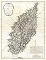 | 3,000 × 3,870 (3.17 MB) | BotMultichillT | {{subst:User:Multichill/Geographicus |link=http://www.geographicus.com/P/AntiqueMap/Corsica-jeffreys-1794 |product_name=1794 Jeffreys Map of Corsica, France |map_title=A New Map of the Island and Kingdom of Corsica. |description=An extraordinary 1794 map |
File usage
The following pages on the English Wikipedia use this file (pages on other projects are not listed):
Global file usage
The following other wikis use this file:
- Usage on ca.wikipedia.org
- Usage on co.wikipedia.org
- Usage on de.wikipedia.org
- Usage on es.wikipedia.org
- Usage on fr.wikipedia.org
- Usage on he.wikipedia.org
- Usage on hu.wikipedia.org
- Usage on id.wikipedia.org
- Usage on it.wikipedia.org
- Usage on nap.wikipedia.org
- Usage on pt.wikipedia.org
- Usage on ru.wikipedia.org
- Usage on sh.wikipedia.org
- Usage on sr.wikipedia.org
- Usage on sv.wikipedia.org
- Usage on vi.wikipedia.org
- Usage on www.wikidata.org
- Usage on zh.wikipedia.org