
File:1789 Estates General map.png

Size of this preview: 585 × 600 pixels. Other resolutions: 234 × 240 pixels | 468 × 480 pixels | 749 × 768 pixels | 999 × 1,024 pixels | 2,000 × 2,050 pixels.
Original file (2,000 × 2,050 pixels, file size: 419 KB, MIME type: image/png)
| This is a file from the Wikimedia Commons. Information from its description page there is shown below. Commons is a freely licensed media file repository. You can help. |
Summary
| Description |
English: A map showing the different types of subdivision that were represented at the Estates-General of 1789. Traced from Brette (1904): Atlas des bailliages ou juridictions assimilées ayant formé unité électorale en 1789
Français : Une carte des divers jurisdictions ayant représentation aux États généraux de 1789. Tracée d'après Brette (1904): Atlas des bailliages ou juridictions assimilées ayant formé unité électorale en 1789
Svenska: En karta som visar de olika indelningar som hade representation i 1789 års generalständer. Ritad utifrån Brette (1904): Atlas des bailliages ou juridictions assimilées ayant formé unité électorale en 1789
Deutsch: Eine Karte vom verschiedenen Gebiete, die auf der Generalstände von 1789 vertretet wurde. Gezeichnet nach Brette (1904): Atlas des bailliages ou juridictions assimilées ayant formé unité électorale en 1789 |
| Date | |
| Source | Own work |
| Author | Max96 |
Licensing
I, the copyright holder of this work, hereby publish it under the following license:
This file is licensed under the Creative Commons Attribution-Share Alike 4.0 International license.
- You are free:
- to share – to copy, distribute and transmit the work
- to remix – to adapt the work
- Under the following conditions:
- attribution – You must give appropriate credit, provide a link to the license, and indicate if changes were made. You may do so in any reasonable manner, but not in any way that suggests the licensor endorses you or your use.
- share alike – If you remix, transform, or build upon the material, you must distribute your contributions under the same or compatible license as the original.
File history
Click on a date/time to view the file as it appeared at that time.
| Date/Time | Thumbnail | Dimensions | User | Comment | |
|---|---|---|---|---|---|
| current | 20:01, 3 January 2021 |  | 2,000 × 2,050 (419 KB) | Max96 | Corrected spelling errors and added English translations where necessary |
| 22:15, 2 January 2021 | 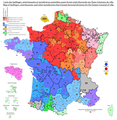 | 2,000 × 2,050 (368 KB) | Max96 | Uploaded own work with UploadWizard |
File usage
The following pages on the English Wikipedia use this file (pages on other projects are not listed):
Global file usage
The following other wikis use this file:
- Usage on da.wikipedia.org
- Usage on de.wikipedia.org
- Usage on fr.wikipedia.org
- Usage on nn.wikipedia.org
- Usage on no.wikipedia.org
- Usage on sv.wikipedia.org