
File:1710 First Japanese Buddhist Map of the World Showing Europe, America, and Africa - Geographicus - NansenBushu-hotan-1710.jpg
Size of this preview: 748 × 599 pixels. Other resolutions: 300 × 240 pixels | 599 × 480 pixels | 958 × 768 pixels | 1,278 × 1,024 pixels | 2,556 × 2,048 pixels | 5,837 × 4,678 pixels.
Original file (5,837 × 4,678 pixels, file size: 7.26 MB, MIME type: image/jpeg)
| This is a file from the Wikimedia Commons. Information from its description page there is shown below. Commons is a freely licensed media file repository. You can help. |
| Title |
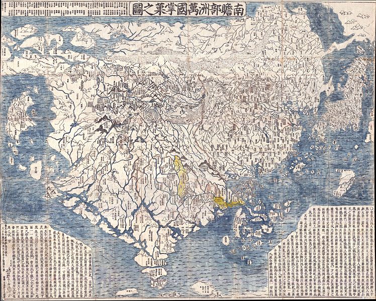
Nansenbushu Bankoku Shoka No Zu (Outline Map of All Countries of the Universe) |
|||||
| Description |
English: A seminal map. This is the first Japanese printed map to depict the world, including Europe and America, from a Buddhist cosmographical perspective. Printed by woodblock in 1710 (Hoei 7), this map was composed by the Buddhist monk Rokashi Hotan. Inspired by the 1653 publication of Si-yu-ki, a pilgrimage narrative of the Chinese monk Hsuang-Tsang's (602-604) travels to India in search of sacred Sanskrit writings, Rokashi Hotan's map attempts to update Buddhist mythological cartography, as exemplified in the 1634 manuscript map Gotenjikuzu (Map of the Five Regions of India), to correspond with the Si-yu-ki, as well as with contemporary and ancient religious texts, Chinese annals, travel narratives, and even some European maps. Rokashi Hotan lists these texts, 102 in all, at the top of the map. The consequent product of Rokashi Hotan's work is this magnificent amalgam of disparate ideas and traditions. In essence this is a traditional Buddhist world view in the Gotenjikuzu mold centered on the world spanning continent of Jambu-Dvipa. At its center is Lake Anavatapta, a whirlpool-like quadruple helix lake believed to be the center of the universe. This lake, which is commonly associated with Lake Manasarovar in northern India, is believed in Buddhist mythology to be the legendary site where Queen Maya conceived the Buddha. From the quadrouple beast headed helix (heads of a horse, a lion, an elephant, and an ox) of Manasarovar or Lake Anavatapta radiate the four sacred rivers of the region: the Indus, the Ganges, the Bramaputra, and the Sutlej. South of Jambu-Dvipa, India is recognizable for in its peninsular form. Japan itself appears as a series of Islands in the upper right and, like India, is one of the few recognizable elements - at least from a cartographic perspective. China and Korea appear to the west of Japan and are vaguely identifiable geographically, which itself represents a significant advancement over the Gotenjikuzu map. Southeast Asia also makes one of its first appearances in a Japanese Buddhist map as an island cluster to the east of India. On the opposite side of the map a series of islands is intended to represent Europe, which had no place at all in earlier Buddhist world maps, making this one of the first Japanese maps to depict Europe. Umukari (Hungary), Oranda, Baratan, Komo (Holland or the country of the red hair), Arubaniya (Albania?), Itarya (Italy), Suransa (France) and Inkeresu (England) are all named. Africa appears as a small island in the western sea identified as the Land of Western Women. Of special note is Rokashi Hotan's mapping of the Americas. Prior to this map America had rarely if ever been depicted on Japanese maps, so Rokashi Hotan turned to the Chinese map Daimin Kyuhen Zu (Map of China under the Ming Dynasty and its surrounding Countries), from which he copied both the small island-like form of South America (just south of Japan), and the curious land bridge (the Aelutian Islands?) connecting Asia to what the Japanese historians Nobuo Muroga and Kazutaka Unno conclude must undoubtedly be a reflection of North America (page 63). Whether this represents ancient knowledge from early Chinese navigations in this region, for which there is some literary if not historical evidence, or merely a printing error, we can only speculate. While this map represents a significant step forward in the Japanese attempt to combine religious and contemporary geographic knowledge it remains in essence a Buddhist map. It is likely that Rokashi Hotan was aware important European style maps circulating in China at the time. The Mateo Ricci Map is one such example and copies were known to have reached Japan in the 17th century. It is curious that Rokashi Hotan chose to ignore it and other Eurocentric data in exchange for a religious world view, while at the same time attempting to reconcile Buddhist and modern geography. |
|||||
| Date | (dated) | |||||
| Source |
|
|||||
| Creator | ||||||
| Permission (Reusing this file) |
|
|||||
| Georeferencing | If inappropriate please set warp_status = skip to hide. | |||||
| Archival data | ||||||
| Accession number |
Geographicus link: NansenBushu-hotan-1710 |
|||||
| Dimensions | height: 45 in (114.3 cm); width: 56.5 in (143.5 cm) | |||||
File history
Click on a date/time to view the file as it appeared at that time.
| Date/Time | Thumbnail | Dimensions | User | Comment | |
|---|---|---|---|---|---|
| current | 00:23, 24 March 2011 |  | 5,837 × 4,678 (7.26 MB) | BotMultichillT | {{subst:User:Multichill/Geographicus |link=http://www.geographicus.com/P/AntiqueMap/NansenBushu-hotan-1710 |product_name=1710 First Japanese Buddhist Map of the World Showing Europe, America, and Africa |map_title=Nansenbushu Bankoku Shoka No Zu (Outlin |
File usage
The following pages on the English Wikipedia use this file (pages on other projects are not listed):
Global file usage
The following other wikis use this file:
- Usage on es.wikipedia.org
- Usage on hi.wikipedia.org
- Usage on it.wikipedia.org
- Usage on www.wikidata.org