
File:13-04-13-st-poelten-landhausviertel-516.jpg

Size of this preview: 800 × 389 pixels. Other resolutions: 320 × 156 pixels | 640 × 311 pixels | 1,024 × 498 pixels | 1,280 × 623 pixels | 2,560 × 1,246 pixels | 4,288 × 2,087 pixels.
Original file (4,288 × 2,087 pixels, file size: 3.05 MB, MIME type: image/jpeg)
| This is a file from the Wikimedia Commons. Information from its description page there is shown below. Commons is a freely licensed media file repository. You can help. |
Summary
| Description |
Deutsch: Landeshauptstadt St. Pölten, Niederösterreich - Landhausviertel English: St. Pölten, Austria, Landhausviertel
|
|||||||||||||||||||||||
| Date | ||||||||||||||||||||||||
| Source | Own work | |||||||||||||||||||||||
| Author |
|
|||||||||||||||||||||||

| Camera location | | View this and other nearby images on: OpenStreetMap |
|---|
Licensing
I, the copyright holder of this work, hereby publish it under the following licenses:

|
Permission is granted to copy, distribute and/or modify this document under the terms of the GNU Free Documentation License, Version 1.2 or any later version published by the Free Software Foundation; with no Invariant Sections, no Front-Cover Texts, and no Back-Cover Texts. A copy of the license is included in the section entitled GNU Free Documentation License. |
This file is licensed under the Creative Commons Attribution 3.0 Unported license.
- You are free:
- to share – to copy, distribute and transmit the work
- to remix – to adapt the work
- Under the following conditions:
- attribution – You must give appropriate credit, provide a link to the license, and indicate if changes were made. You may do so in any reasonable manner, but not in any way that suggests the licensor endorses you or your use.
You may select the license of your choice.
File history
Click on a date/time to view the file as it appeared at that time.
| Date/Time | Thumbnail | Dimensions | User | Comment | |
|---|---|---|---|---|---|
| current | 13:17, 2 May 2013 | 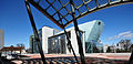 | 4,288 × 2,087 (3.05 MB) | Ralf Roletschek | verzerrt, Sensorflecken, geschärft |
| 11:51, 15 April 2013 | 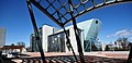 | 4,288 × 2,087 (2.66 MB) | Ralf Roletschek | beschnitten | |
| 19:23, 14 April 2013 |  | 4,288 × 2,848 (5.75 MB) | Ralf Roletschek |
File usage
The following pages on the English Wikipedia use this file (pages on other projects are not listed):
Global file usage
The following other wikis use this file:
- Usage on ca.wikipedia.org
- Usage on cs.wikipedia.org
- Usage on de.wikipedia.org
- Usage on de.wikivoyage.org
- Usage on et.wikipedia.org
- Usage on fi.wikipedia.org
- Usage on fr.wikipedia.org
- Usage on hr.wikipedia.org
- Usage on hu.wikipedia.org
- Usage on it.wikipedia.org
- Usage on sl.wikipedia.org
- Usage on vi.wikipedia.org