
File:Rhön - Deutsche Mittelgebirge, Serie A-de.png

Original file (1,800 × 2,000 pixels, file size: 4.92 MB, MIME type: image/png)
| This is a file from the Wikimedia Commons. Information from its description page there is shown below. Commons is a freely licensed media file repository. You can help. |
Summary
| Description |
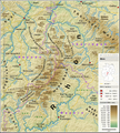
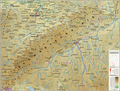
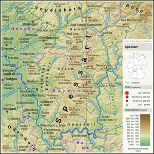
English: Topographic map of the Rhön Mountains
Deutsch: Topografische Karte der Rhön |
||||||||||||||||||
| Date | |||||||||||||||||||
| Source |
Own work using: |
||||||||||||||||||
| Author | Thoroe | ||||||||||||||||||
| Other versions |
 Topographic maps of German low mountain ranges (A series)
This map series aims to show the major low mountain ranges of Germany in a uniform design. All maps are created on the same scale, and the background reliefs base upon the same color scheme. The reliefs are also available as separate files. You can find the making-of one of the maps in the German language Wikipedia (German only).
|
||||||||||||||||||


| This work contains information from OpenStreetMap, which is made available under the Open Database License (ODbL).
The ODbL does not require any particular license for maps produced from ODbL data. Prior to 1 August 2020, map tiles produced by the OpenStreetMap Foundation were licensed under the CC-BY-SA-2.0 license. Maps produced by other people may be subject to other licences. |

|
This map has been made or improved in the German Kartenwerkstatt (Map Lab). You can propose maps to improve as well.
|
Licensing
- You are free:
- to share – to copy, distribute and transmit the work
- to remix – to adapt the work
- Under the following conditions:
- attribution – You must give appropriate credit, provide a link to the license, and indicate if changes were made. You may do so in any reasonable manner, but not in any way that suggests the licensor endorses you or your use.
- share alike – If you remix, transform, or build upon the material, you must distribute your contributions under the same or compatible license as the original.
| Annotations | This image is annotated: View the annotations at Commons |


File history
Click on a date/time to view the file as it appeared at that time.
| Date/Time | Thumbnail | Dimensions | User | Comment | |
|---|---|---|---|---|---|
| current | 20:09, 20 May 2016 |  | 1,800 × 2,000 (4.92 MB) | Thoroe | font sizes |
| 19:22, 11 May 2016 |  | 1,800 × 2,000 (4.97 MB) | Thoroe | minor fixes | |
| 21:19, 8 May 2016 |  | 1,800 × 2,000 (4.96 MB) | Thoroe | +Orte +BAB-Nummern etc. | |
| 12:39, 7 May 2016 |  | 1,800 × 2,000 (4.94 MB) | Thoroe | minor fixes | |
| 23:24, 5 May 2016 | 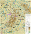 | 1,800 × 2,000 (4.94 MB) | Thoroe | {{Information |Description ={{en|1=Topographic map of the Rhön Mountains}} {{de|1=Topografische Karte der Rhön}} |Source ={{Own using}} *[http://gmt.soest.hawaii.edu Generic Mapping Tools (GMT)] with S... |
File usage
Global file usage
The following other wikis use this file:
- Usage on bg.wikipedia.org
- Usage on de.wikipedia.org
- Usage on es.wikipedia.org
- Usage on fa.wikipedia.org
- Usage on fr.wikipedia.org
- Usage on nl.wikipedia.org
- Usage on no.wikipedia.org
- Usage on pl.wikipedia.org
- Usage on pl.wikivoyage.org
- Usage on www.wikidata.org