
File:Polity data series map 2011.svg

Size of this PNG preview of this SVG file: 800 × 340 pixels. Other resolutions: 320 × 136 pixels | 640 × 272 pixels | 1,024 × 435 pixels | 1,280 × 544 pixels | 2,560 × 1,088 pixels | 842 × 358 pixels.
Original file (SVG file, nominally 842 × 358 pixels, file size: 1.39 MB)
| This is a file from the Wikimedia Commons. Information from its description page there is shown below. Commons is a freely licensed media file repository. You can help. |
Summary
| Description |
English: Map of Polity IV 2011 data displaying the POLITY score, obtained by subtracting the authoritarian score of a country from the respective democracy score. Darkest red is the lowest score (-10), darkest blue the highest(10), purple is zero. |
| Date | |
| Source |
Derived from: |
| Author | Dishcmds |
Licensing
| I, the copyright holder of this work, release this work into the public domain. This applies worldwide. In some countries this may not be legally possible; if so: I grant anyone the right to use this work for any purpose, without any conditions, unless such conditions are required by law. |
File history
Click on a date/time to view the file as it appeared at that time.
| Date/Time | Thumbnail | Dimensions | User | Comment | |
|---|---|---|---|---|---|
| current | 12:42, 22 October 2013 |  | 842 × 358 (1.39 MB) | Daranz | Revise color scheme for more contrast between extreme ends of the scale |
| 23:44, 24 February 2013 |  | 842 × 358 (1.39 MB) | Dishcmds | Cropped, added legend, slight color tweaks. | |
| 10:30, 18 February 2013 | 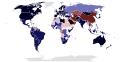 | 863 × 443 (1.59 MB) | Dishcmds | Added Sudan and South Sudan and changed colors. | |
| 17:44, 16 February 2013 |  | 863 × 443 (1.58 MB) | Dishcmds | User created page with UploadWizard |
File usage
The following pages on the English Wikipedia use this file (pages on other projects are not listed):
Global file usage
The following other wikis use this file:
- Usage on fr.wikipedia.org
- Usage on ka.wikipedia.org
- Usage on zh.wikipedia.org