
File:NOAA GOES West GEOCOLOR Hunga Tonga optimized.gif

Size of this preview: 800 × 480 pixels. Other resolutions: 320 × 192 pixels | 900 × 540 pixels.
Original file (900 × 540 pixels, file size: 28.93 MB, MIME type: image/gif, looped, 152 frames, 15 s)
| This is a file from the Wikimedia Commons. Information from its description page there is shown below. Commons is a freely licensed media file repository. You can help. |
Summary
| Description |
English: This is a 24-hour animation of the Hunga Tonga eruption, showing the initial eruption around 4:00 UTC January 15th, and the ash cloud fully dissipated around 00:00 UTC January 16th |
| Date | Taken on 15 January 2022, 03:20 UTC through 16 January 2022, 04:50 UTC |
| Source | https://www.star.nesdis.noaa.gov/GOES/sector_band.php?sat=G17§or=tsp&band=GEOCOLOR&length=24&dim=0 |
| Author | NOAA/NESDIS/STAR |
Licensing
This image is in the public domain because it contains materials that originally came from the U.S. National Oceanic and Atmospheric Administration, taken or made as part of an employee's official duties.
|
File history
Click on a date/time to view the file as it appeared at that time.
| Date/Time | Thumbnail | Dimensions | User | Comment | |
|---|---|---|---|---|---|
| current | 08:02, 16 January 2022 | 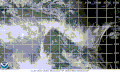 | 900 × 540 (28.93 MB) | MrAureliusR | Uploaded a work by National Oceanic and Atmospheric Administration from https://www.star.nesdis.noaa.gov/GOES/sector_band.php?sat=G17§or=tsp&band=GEOCOLOR&length=24&dim=0 with UploadWizard |
File usage
The following pages on the English Wikipedia use this file (pages on other projects are not listed):
Global file usage
The following other wikis use this file:
- Usage on de.wikipedia.org