
File:Ireland location provinces.svg

Size of this PNG preview of this SVG file: 400 × 500 pixels. Other resolutions: 192 × 240 pixels | 384 × 480 pixels | 614 × 768 pixels | 819 × 1,024 pixels | 1,638 × 2,048 pixels.
Original file (SVG file, nominally 400 × 500 pixels, file size: 335 KB)
| This is a file from the Wikimedia Commons. Information from its description page there is shown below. Commons is a freely licensed media file repository. You can help. |
Summary
| Description |
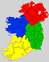
English: A map highlighting the four provinces of Ireland. Ulster
Connacht
Leinster
Munster |
| Date | (UTC) |
| Source |
This file was derived from: |
| Author |
|
| This is a retouched picture, which means that it has been digitally altered from its original version. The original can be viewed here: Ireland location provinces.jpg:
|
Licensing
I, the copyright holder of this work, hereby publish it under the following license:
| I, the copyright holder of this work, release this work into the public domain. This applies worldwide. In some countries this may not be legally possible; if so: I grant anyone the right to use this work for any purpose, without any conditions, unless such conditions are required by law. |
Original upload log
This image is a derivative work of the following images:
- File:Ireland_location_provinces.jpg licensed with PD-self
- 2009-12-14T21:28:00Z Asarlaí 1792x2258 (921967 Bytes) {{Information |Description={{en|1=A map highlighting the four provinces of Ireland.}} |Source=Based on an outline map of Ireland. |Author=[[User:Asarlaí]] |Date=2009-12-14 |Permission= |other_versions= }} [[Category:Maps of
Uploaded with derivativeFX
File history
Click on a date/time to view the file as it appeared at that time.
| Date/Time | Thumbnail | Dimensions | User | Comment | |
|---|---|---|---|---|---|
| current | 13:52, 25 September 2020 |  | 400 × 500 (335 KB) | Draceane | -background |
| 13:43, 25 September 2020 |  | 400 × 500 (362 KB) | Draceane | cleanup, colorblind version | |
| 16:23, 1 December 2018 |  | 1,776 × 2,209 (2.4 MB) | Draceane | -JPEG artifacts mapped to SVG | |
| 03:59, 8 May 2012 |  | 1,776 × 2,209 (2.4 MB) | Ninrouter | == {{int:filedesc}} == {{Information |Description={{en|1=A map highlighting the four provinces of Ireland.}} |Source={{Derived from|Ireland_location_provinces.jpg|display=50}} |Date=2012-05-08 03:53 (UTC) |Author=*[[:File:Ireland_location_provinces.jpg... |
File usage
The following pages on the English Wikipedia use this file (pages on other projects are not listed):
Global file usage
The following other wikis use this file:
- Usage on be.wikipedia.org
- Usage on br.wikipedia.org
- Usage on cs.wikipedia.org
- Usage on el.wikipedia.org
- Usage on es.wikipedia.org
- Usage on fr.wikipedia.org
- Usage on ga.wikipedia.org
- Usage on gd.wikipedia.org
- Usage on gv.wikipedia.org
- Usage on incubator.wikimedia.org
- Usage on io.wikipedia.org
- Usage on ja.wikipedia.org
- Usage on ka.wikipedia.org
- Usage on no.wikipedia.org
- Usage on pt.wikipedia.org
- Usage on ru.wikipedia.org
- Usage on sco.wikipedia.org
- Usage on sk.wikipedia.org
- Usage on sr.wikipedia.org
- Usage on tr.wikipedia.org
- Usage on uk.wikipedia.org
- Usage on ur.wikipedia.org
- Usage on vi.wikipedia.org
- Usage on zh-yue.wikipedia.org
- Usage on zh.wikipedia.org