
File:Indian Fields Methodist Campground, Aerial View, SC Route 73, .7 mile from SC Route 15, Saint George vicinity (Dorchester County, South Carolina).jpg

No higher resolution available.
Indian_Fields_Methodist_Campground,_Aerial_View,_SC_Route_73,_.7_mile_from_SC_Route_15,_Saint_George_vicinity_(Dorchester_County,_South_Carolina).jpg (577 × 405 pixels, file size: 114 KB, MIME type: image/jpeg)
| This is a file from the Wikimedia Commons. Information from its description page there is shown below. Commons is a freely licensed media file repository. You can help. |
| Description |
English: Indian Fields Methodist Campground, Aerial View, SC Route 73, .7 mile from SC Route 15, Saint George vicinity (Dorchester County, South Carolina) - cropped
|
||||||||
| Date | Unknown date | ||||||||
| Source | http://memory.loc.gov/cgi-bin/displayPhoto.pl?path=/pnp/habshaer/sc/sc0700/sc0736/photos&topImages=149815pr.jpg&topLinks=149815pv.jpg,149815pu.tif&title=35.%20%20AERIAL%20VIEW,%205'%20X%207'%20COPY%20NEGATIVE%20(NATIONAL%20REGISTER)%20%20%20%20%20%20%20%20%20%20%20%20%20%20%20%3cbr%3eHABS%20SC,18-SAGEO,1-35&displayProfile=0 | ||||||||
| Author | National Register |


File history
Click on a date/time to view the file as it appeared at that time.
| Date/Time | Thumbnail | Dimensions | User | Comment | |
|---|---|---|---|---|---|
| current | 22:04, 21 April 2009 | 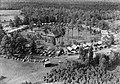 | 577 × 405 (114 KB) | KudzuVine | {{Information |Description={{en|1=Indian Fields Methodist Campground, Aerial View, SC Route 73, .7 mile from SC Route 15, Saint George vicinity (Dorchester County, South Carolina) - cropped {{HABS|SC,18-SAGEO,1-35}} {{PD-USGov-Interior}}}} |Source=http:/ |
File usage
The following pages on the English Wikipedia use this file (pages on other projects are not listed):
Global file usage
The following other wikis use this file:
- Usage on de.wikipedia.org
- Usage on es.wikipedia.org