
File:Hypothetical map illustrating Belgium divided into Wallonia and the Netherlands.svg

Size of this PNG preview of this SVG file: 688 × 600 pixels. Other resolutions: 275 × 240 pixels | 551 × 480 pixels | 881 × 768 pixels | 1,175 × 1,024 pixels | 2,350 × 2,048 pixels | 1,137 × 991 pixels.
Original file (SVG file, nominally 1,137 × 991 pixels, file size: 154 KB)
| This is a file from the Wikimedia Commons. Information from its description page there is shown below. Commons is a freely licensed media file repository. You can help. |
Summary
| Description |
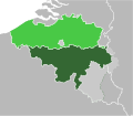
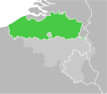
English: Hypothetical map illustrating Belgium divided into Wallonia and the Netherlands (through the unification of Flanders with the Netherlands), by modern boundaries.
Brussels-Capital Region - undefined Wallonia - independent state of Wallonia / continuation of Belgium Flanders - unification with the Netherlands |
| Date | |
| Source | Derived from File:Deutschsprachige Gemeinschaft in Belgium.svg |
| Author | Rob984 |
| Other versions |
|


Licensing
I, the copyright holder of this work, hereby publish it under the following license:
This file is licensed under the Creative Commons Attribution-Share Alike 4.0 International license.
- You are free:
- to share – to copy, distribute and transmit the work
- to remix – to adapt the work
- Under the following conditions:
- attribution – You must give appropriate credit, provide a link to the license, and indicate if changes were made. You may do so in any reasonable manner, but not in any way that suggests the licensor endorses you or your use.
- share alike – If you remix, transform, or build upon the material, you must distribute your contributions under the same or compatible license as the original.
File history
Click on a date/time to view the file as it appeared at that time.
| Date/Time | Thumbnail | Dimensions | User | Comment | |
|---|---|---|---|---|---|
| current | 16:53, 5 January 2017 |  | 1,137 × 991 (154 KB) | Rob984 | User created page with UploadWizard |
File usage
The following pages on the English Wikipedia use this file (pages on other projects are not listed):