
File:Hampton VA satellite map.jpg

Size of this preview: 412 × 600 pixels. Other resolutions: 165 × 240 pixels | 581 × 846 pixels.
Original file (581 × 846 pixels, file size: 74 KB, MIME type: image/jpeg)
| This is a file from the Wikimedia Commons. Information from its description page there is shown below. Commons is a freely licensed media file repository. You can help. |
| Description |
English: Satellite image of Hampton, Virginia |
| Date | |
| Source | Imagery by NASA and/or the US Geological Survey. Processed by Terra Prints Inc. |
| Author | Terra Prints Inc. |
| Permission (Reusing this file) |
I, the copyright holder of this work, hereby publish it under the following license:
This file is licensed under the Creative Commons Attribution-Share Alike 2.5 Generic license.
- You are free:
- to share – to copy, distribute and transmit the work
- to remix – to adapt the work
- Under the following conditions:
- attribution – You must give appropriate credit, provide a link to the license, and indicate if changes were made. You may do so in any reasonable manner, but not in any way that suggests the licensor endorses you or your use.
- share alike – If you remix, transform, or build upon the material, you must distribute your contributions under the same or compatible license as the original.
File history
Click on a date/time to view the file as it appeared at that time.
| Date/Time | Thumbnail | Dimensions | User | Comment | |
|---|---|---|---|---|---|
| current | 14:45, 22 February 2009 | 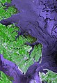 | 581 × 846 (74 KB) | Cropbot | upload cropped version, operated by User:Finavon. Summary: border/caption cropped |
| 03:32, 22 October 2006 |  | 669 × 1,000 (86 KB) | Rolandc73 | {{Information |Description=Imagery by NASA and/or the US Geological Survey. Processed by Terra Prints Inc. Satellite image of Hampton, Virginia |Source=http://www.terraprints.com |Date=2006-10-21 |Author=Terra Prints Inc. |Permission=Own work, share alike |
File usage
The following pages on the English Wikipedia use this file (pages on other projects are not listed):