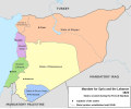
File:French Mandate for Syria and the Lebanon map en.svg
Appearance

Size of this PNG preview of this SVG file: 725 × 599 pixels. Other resolutions: 290 × 240 pixels | 581 × 480 pixels | 929 × 768 pixels | 1,239 × 1,024 pixels | 2,478 × 2,048 pixels | 922 × 762 pixels.
Original file (SVG file, nominally 922 × 762 pixels, file size: 245 KB)
File history
Click on a date/time to view the file as it appeared at that time.
| Date/Time | Thumbnail | Dimensions | User | Comment | |
|---|---|---|---|---|---|
| current | 16:05, 4 February 2013 |  | 922 × 762 (245 KB) | AnonMoos | Change "Libanon" to "Lebanon" |
| 15:33, 4 February 2013 |  | 922 × 762 (250 KB) | Don-kun | fix border to palestine, source: http://en.wikisource.org/wiki/Franco-British_Convention_on_Certain_Points_Connected_with_the_Mandates_for_Syria_and_the_Lebanon,_Palestine_and_Mesopotamia | |
| 18:43, 30 January 2013 |  | 922 × 762 (248 KB) | Don-kun | minus ahistorical lakes (and so all waterbodies) | |
| 21:44, 26 January 2013 |  | 922 × 762 (282 KB) | Don-kun | {{Information |Description ={{en|1=Map of French Mandate for Syria and the Lebanon and the states created in 1922, in English.}} |Source ={{own}}, based on File:Syria, administrative divisions - de - colored.svg |Author =[[User:... |
File usage
The following 57 pages use this file:
- 1925 Hama uprising
- 1936 Syrian general strike
- Abd al-Rahman Shahbandar
- Al-Jazira Province
- Alawite State
- Alawite revolt of 1919
- Alawites
- Ayyash Al-Haj
- Battle of Maysalun
- Battle of al-Kafr
- Battle of al-Mazraa
- Battle of al-Musayfirah
- Capture of Damascus (1920)
- Capture of Salkhad
- Epic of Ain Albu Gomaa
- Fawzi al-Qawuqji
- Federalization of Syria
- Franco-Syrian Treaty of Independence
- Franco-Syrian War
- Great Syrian Revolt
- Greater Lebanon
- Hananu Revolt
- Haqqi al-Azm
- Hasan al-Kharrat
- Hashim al-Atassi
- Hatay State
- Henri Ponsot
- Henry de Jouvenel
- High Commissioner of the Levant
- History of Lebanon
- History of Syria
- Ibrahim Hananu
- Jabal Druze State
- Jamil Mardam Bey
- Kamil Pasha al-Qudsi
- Khalid al-Azm
- Lebanon
- Lebanon–Syria border
- Lebanon–Syria relations
- Levant Crisis
- Mandate for Syria and the Lebanon
- Maxime Weygand
- Mustafa Bey Barmada
- Partition of the Ottoman Empire
- Saleh al-Ali
- Sanjak of Alexandretta
- Shukri al-Quwatli
- State of Aleppo
- State of Damascus
- State of Syria (1925–1930)
- Sultan al-Atrash
- Syria–Lebanon campaign
- Tayfur Sökmen
- Yusuf al-Azma
- User:Falcaorib/Contemporary Empires (1800-2024 AD)
- User:W144756u/sandbox
- Template:French Mandate of Syria
Global file usage
The following other wikis use this file:
- Usage on af.wikipedia.org
- Usage on ar.wikipedia.org
- Usage on ast.wikipedia.org
- Usage on azb.wikipedia.org
- Usage on az.wikipedia.org
- Usage on be-tarask.wikipedia.org
- Usage on be.wikipedia.org
- Usage on bg.wikipedia.org
- Usage on bn.wikipedia.org
- Usage on cs.wikipedia.org
- Usage on de.wikipedia.org
- Usage on el.wikipedia.org
- Usage on eo.wikipedia.org
- Usage on eu.wikipedia.org
- Usage on fa.wikipedia.org
View more global usage of this file.


