
File:Ellsworth Land - Palmer Land.jpg

Size of this preview: 776 × 600 pixels. Other resolutions: 311 × 240 pixels | 621 × 480 pixels | 994 × 768 pixels | 1,280 × 989 pixels | 2,560 × 1,978 pixels | 4,096 × 3,165 pixels.
Original file (4,096 × 3,165 pixels, file size: 1.35 MB, MIME type: image/jpeg)
| This is a file from the Wikimedia Commons. Information from its description page there is shown below. Commons is a freely licensed media file repository. You can help. |
Summary
| Description |
English: East part of Ellsworth Land, South part of Palmer Land, Antarctica |
| Date | |
| Source | https://data.pgc.umn.edu/maps/antarctica/usgs/08/preview/Ellsworth%20Land%20to%20Palmer%20Land.jpg |
| Author | USGS |
Licensing
This work is in the public domain in the United States because it is a work prepared by an officer or employee of the United States Government as part of that person’s official duties under the terms of Title 17, Chapter 1, Section 105 of the US Code.
Note: This only applies to original works of the Federal Government and not to the work of any individual U.S. state, territory, commonwealth, county, municipality, or any other subdivision. This template also does not apply to postage stamp designs published by the United States Postal Service since 1978. (See § 313.6(C)(1) of Compendium of U.S. Copyright Office Practices). It also does not apply to certain US coins; see The US Mint Terms of Use.
|
 | |
| This file has been identified as being free of known restrictions under copyright law, including all related and neighboring rights. | ||
File history
Click on a date/time to view the file as it appeared at that time.
| Date/Time | Thumbnail | Dimensions | User | Comment | |
|---|---|---|---|---|---|
| current | 18:36, 21 April 2024 | 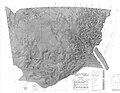 | 4,096 × 3,165 (1.35 MB) | Aymatth2 | Uploaded a work by USGS from https://data.pgc.umn.edu/maps/antarctica/usgs/08/preview/Ellsworth%20Land%20to%20Palmer%20Land.jpg with UploadWizard |
File usage
The following 22 pages use this file:
- Behrendt Mountains
- Carey Range
- Dana Mountains
- Gardner Inlet
- Grossman Nunataks
- Guettard Range
- Hauberg Mountains
- Hutton Mountains
- Kemp Peninsula
- Latady Mountains
- Lyon Nunataks
- Merrick Mountains
- New Bedford Inlet
- Piggott Peninsula
- Playfair Mountains
- Scaife Mountains
- Sky-Hi Nunataks
- Smith Peninsula
- Sweeney Mountains
- Werner Mountains
- Wright Inlet
- Yee Nunataks
Global file usage
The following other wikis use this file:
- Usage on it.wikipedia.org
- Ghiacciaio Barcus
- Ghiacciaio Bryan
- Ghiacciaio Douglas
- Ghiacciaio Haines
- Ghiacciaio Irvine
- Ghiacciaio Johnston
- Ghiacciaio Ketchum
- Ghiacciaio Matthews
- Ghiacciaio Meinardus
- Ghiacciaio Spear
- Ghiacciaio Squires
- Ghiacciaio Srite
- Ghiacciaio Strange
- Ghiacciaio Swann
- Ghiacciaio Ueda
- Ghiacciaio Waverly
- Ghiacciaio Wells
- Ghiacciaio Wetmore
- Insenatura di Gardner
- Insenatura di Wright
- Insenatura New Bedford
- Insenatura Nantucket
- Penisola Smith
- Insenatura di Howkins
- Insenatura di Mossman
- Insenatura di Keller
- Insenatura di Hansen
- Monti Merrick
- Monti Behrendt
- Monti Sweeney
- Monti Scaife
- Monti Latady
- Dorsale RARE
- Dorsale Guettard
- Monti Werner
- Monti Playfair
- Monti Dana
- Monti Hutton
- Monti Hauberg