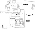
File:El Chal map of site core.jpg
Appearance

Size of this preview: 718 × 600 pixels. Other resolutions: 287 × 240 pixels | 575 × 480 pixels | 919 × 768 pixels | 1,226 × 1,024 pixels | 2,000 × 1,671 pixels.
Original file (2,000 × 1,671 pixels, file size: 371 KB, MIME type: image/jpeg)
File history
Click on a date/time to view the file as it appeared at that time.
| Date/Time | Thumbnail | Dimensions | User | Comment | |
|---|---|---|---|---|---|
| current | 22:28, 17 November 2010 |  | 2,000 × 1,671 (371 KB) | Simon Burchell | {{Information |Description={{en|1=Map of the site core of the Maya archaeological site of El Chal, Dolores, Peten, Guatemala. Compiled from various reports by the ''Atlas Arqueológico de Guatemala'', paritcularly those written by Paulino Morales and by M |
File usage
The following page uses this file:
Global file usage
The following other wikis use this file:
- Usage on de.wikivoyage.org
- Usage on es.wikipedia.org
