
File:Cascade Range geology detail.png

No higher resolution available.
Cascade_Range_geology_detail.png (416 × 414 pixels, file size: 32 KB, MIME type: image/png)
| This is a file from the Wikimedia Commons. Information from its description page there is shown below. Commons is a freely licensed media file repository. You can help. |
Summary
| Description |
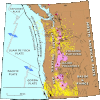
English: Detailed geological map of the Cascade Range and environs. Yellow rings indicate recorded earthquakes. Black lines show faults active within past 10,000 years. |
| Date | |
| Source | Archived source link |
| Author | USGS |
| Permission (Reusing this file) |
PD-USGov-USGS |
| Other versions |
Licensing
This image is in the public domain in the United States because it only contains materials that originally came from the United States Geological Survey, an agency of the United States Department of the Interior. For more information, see the official USGS copyright policy.
|
File history
Click on a date/time to view the file as it appeared at that time.
| Date/Time | Thumbnail | Dimensions | User | Comment | |
|---|---|---|---|---|---|
| current | 18:17, 12 May 2013 |  | 416 × 414 (32 KB) | Hike395 | {{Information |Description ={{en|1=Detailed geological map of the Cascade Range and environs. Yellow rings indicate recorded earthquakes. Black lines show faults active within past 10,000 years.}} |Source =http://geomaps.wr.usgs.gov/parks/pr... |
File usage
No pages on the English Wikipedia use this file (pages on other projects are not listed).