
File:Canada Population density map.jpg

Size of this preview: 800 × 544 pixels. Other resolutions: 320 × 218 pixels | 640 × 436 pixels | 958 × 652 pixels.
Original file (958 × 652 pixels, file size: 224 KB, MIME type: image/jpeg)
| This is a file from the Wikimedia Commons. Information from its description page there is shown below. Commons is a freely licensed media file repository. You can help. |
Summary
| Description |
English: Modified map with interior US borders removed to show only Canadian portion of map |
| Date | |
| Source | File:Us_population_2005_lrg.jpg based on http://earthobservatory.nasa.gov/IOTD/view.php?id=7052 |
| Author | Original image: w:NASA . Cropping & border modifications: own work |
Licensing
This file is licensed under the Creative Commons Attribution-Share Alike 4.0 International license.
- You are free:
- to share – to copy, distribute and transmit the work
- to remix – to adapt the work
- Under the following conditions:
- attribution – You must give appropriate credit, provide a link to the license, and indicate if changes were made. You may do so in any reasonable manner, but not in any way that suggests the licensor endorses you or your use.
- share alike – If you remix, transform, or build upon the material, you must distribute your contributions under the same or compatible license as the original.
File history
Click on a date/time to view the file as it appeared at that time.
| Date/Time | Thumbnail | Dimensions | User | Comment | |
|---|---|---|---|---|---|
| current | 17:53, 28 April 2018 | 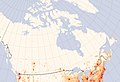 | 958 × 652 (224 KB) | MarginalCost | User created page with UploadWizard |
File usage
The following pages on the English Wikipedia use this file (pages on other projects are not listed):