
File:British Map showing position of British and American troops in and around New York Island on 27th of August 1776.jpg

Size of this preview: 537 × 599 pixels. Other resolutions: 215 × 240 pixels | 430 × 480 pixels | 688 × 768 pixels | 918 × 1,024 pixels | 1,836 × 2,048 pixels | 6,246 × 6,968 pixels.
Original file (6,246 × 6,968 pixels, file size: 10.4 MB, MIME type: image/jpeg)
| This is a file from the Wikimedia Commons. Information from its description page there is shown below. Commons is a freely licensed media file repository. You can help. |
Summary
| Description |
English: A plan of New York Island, with part of Long Island, Staten Island, and East New Jersey, with a particular description of the engagement on the Woody Heights of Long Island, between Flatbush and Brooklyn, on 27 August 1776, between His Majesty's forces, commanded by General Howe and the Americans under General Putman. Shewing [sic] also the landing of the British Army on New York Island and the taking of the city of New York etc. on 15 September following, with the subsequent disposition of both the armies.
Engraved and published according to Act of Parliament Oct 19 1776 by Wm. Fadden, successor to the late Mr Ts. Jeffreys, geographer to the King, Charing Cross, London. |
| Date | |
| Source |
https://collections.leventhalmap.org/search/commonwealth:cj82m115h Norman B. Leventhal Map & Education Center at the Boston Public Library |
| Author | William Fadden (1749-1836) |
Licensing
|
This work is in the public domain in its country of origin and other countries and areas where the copyright term is the author's life plus 70 years or fewer. This work is in the public domain in the United States because it was published (or registered with the U.S. Copyright Office) before January 1, 1929. | |
| This file has been identified as being free of known restrictions under copyright law, including all related and neighboring rights. | |
File history
Click on a date/time to view the file as it appeared at that time.
| Date/Time | Thumbnail | Dimensions | User | Comment | |
|---|---|---|---|---|---|
| current | 18:21, 13 October 2020 | 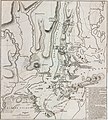 | 6,246 × 6,968 (10.4 MB) | Ykraps | Uploaded a work by William Fadden (1749-1836) from https://collections.leventhalmap.org/search/commonwealth:cj82m115h Norman B. Leventhal Map & Education Center at the Boston Public Library with UploadWizard |
File usage
The following pages on the English Wikipedia use this file (pages on other projects are not listed):