
File:Blythburgh plan 1770 Cleer S. Alger.jpg

Size of this preview: 355 × 599 pixels. Other resolutions: 142 × 240 pixels | 462 × 780 pixels.
Original file (462 × 780 pixels, file size: 71 KB, MIME type: image/jpeg)
| This is a file from the Wikimedia Commons. Information from its description page there is shown below. Commons is a freely licensed media file repository. You can help. |
Summary
| Description |
English: Plan of the site of Blythburgh Abbey |
| Date | |
| Source | File:Proceedings of the Suffolk Institute of Archæology and Natural History (IA proceedingsofsuf04unse).pdf |
| Author | Cleer Sewell Alger |
Object location
| | View this and other nearby images on: OpenStreetMap |
Licensing
|
This work is in the public domain in its country of origin and other countries and areas where the copyright term is the author's life plus 70 years or fewer. | |
| This file has been identified as being free of known restrictions under copyright law, including all related and neighboring rights. | |
File history
Click on a date/time to view the file as it appeared at that time.
| Date/Time | Thumbnail | Dimensions | User | Comment | |
|---|---|---|---|---|---|
| current | 16:08, 21 March 2024 | 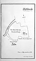 | 462 × 780 (71 KB) | Leutha | Uploaded a work by Cleer Sewell Alger from File:Proceedings of the Suffolk Institute of Archæology and Natural History (IA proceedingsofsuf04unse).pdf with UploadWizard |
File usage
The following pages on the English Wikipedia use this file (pages on other projects are not listed):