
File:Belgian Railway Line 54.png
Size of this preview: 800 × 566 pixels. Other resolutions: 320 × 226 pixels | 640 × 453 pixels | 1,024 × 724 pixels | 1,280 × 905 pixels | 1,558 × 1,102 pixels.
Original file (1,558 × 1,102 pixels, file size: 2.19 MB, MIME type: image/png)
| This is a file from the Wikimedia Commons. Information from its description page there is shown below. Commons is a freely licensed media file repository. You can help. |
Summary
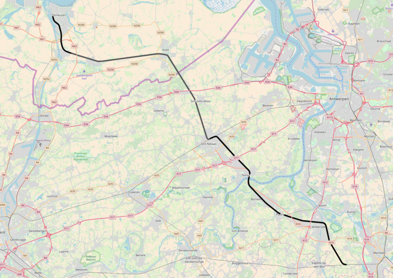
| Description | Belgian Railway Line 54, Y Heike - Terneuzen |
| Date | |
| Source | Own work |
| Author | OpenStreetMap contributors |
Licensing
I, the copyright holder of this work, hereby publish it under the following licenses:

|
Permission is granted to copy, distribute and/or modify this document under the terms of the GNU Free Documentation License, Version 1.2 or any later version published by the Free Software Foundation; with no Invariant Sections, no Front-Cover Texts, and no Back-Cover Texts. A copy of the license is included in the section entitled GNU Free Documentation License. |
This file is licensed under the Creative Commons Attribution-Share Alike 3.0 Unported, 2.5 Generic, 2.0 Generic and 1.0 Generic license.
- You are free:
- to share – to copy, distribute and transmit the work
- to remix – to adapt the work
- Under the following conditions:
- attribution – You must give appropriate credit, provide a link to the license, and indicate if changes were made. You may do so in any reasonable manner, but not in any way that suggests the licensor endorses you or your use.
- share alike – If you remix, transform, or build upon the material, you must distribute your contributions under the same or compatible license as the original.
You may select the license of your choice.
File history
Click on a date/time to view the file as it appeared at that time.
| Date/Time | Thumbnail | Dimensions | User | Comment | |
|---|---|---|---|---|---|
| current | 18:20, 26 November 2017 |  | 1,558 × 1,102 (2.19 MB) | Vunz | fix |
| 20:27, 5 May 2016 |  | 1,449 × 1,091 (2.31 MB) | Vunz | greyed out former track | |
| 08:52, 19 May 2014 |  | 1,449 × 1,091 (2.31 MB) | Vunz | improved | |
| 15:27, 2 September 2010 |  | 1,133 × 709 (1.13 MB) | Vunz | ||
| 18:36, 8 December 2009 |  | 1,133 × 709 (1.13 MB) | Vunz | == {{int:filedesc}} == {{Information |Description= spoorlijn 54, Y Heike - Terneuzen |Source= [http://openstreetmap.org openstreetmap.org]. |Date=2009-12-08 |Author= OpenStreetMap contributors |Permission= All OpenStreetMap data and maps are Creative Comm | |
| 19:50, 24 January 2009 |  | 520 × 390 (35 KB) | Vunz | {{Information |Description={{nl|1=spoormap lijn 54}} |Source=eigen werk (own work) |Author=Wiebevl |Date=24/01/2009 |Permission= |other_versions= }} <!--{{ImageUpload|full}}--> Category:Rail transport maps of Belgium [[Category:Publi |
File usage
The following pages on the English Wikipedia use this file (pages on other projects are not listed):
Global file usage
The following other wikis use this file:
- Usage on fr.wikipedia.org
- Usage on nl.wikipedia.org
- Usage on www.wikidata.org
- Usage on zea.wikipedia.org