
File:Ambulyx obliterata MHNT CUT 2010 0 157 Taiping, Perak, Malaysia male.jpg

Size of this preview: 574 × 600 pixels. Other resolutions: 230 × 240 pixels | 459 × 480 pixels | 735 × 768 pixels | 980 × 1,024 pixels | 1,960 × 2,048 pixels | 6,374 × 6,661 pixels.
Original file (6,374 × 6,661 pixels, file size: 12.82 MB, MIME type: image/jpeg)
| This is a file from the Wikimedia Commons. Information from its description page there is shown below. Commons is a freely licensed media file repository. You can help. |
|
Ambulyx obliterata Rothschild, 1920 |
| Photographer | ||||||||||||||||||||||||
| Description |
Deutsch: Ambulyx obliterata - Zwei Ansichten des gleichen Exemplars
English: Ambulyx obliterata - Two views of same specimen
Français : Ambulyx obliterata - Deux vues du même spécimen
|
|||||||||||||||||||||||
| Gender | Male | |||||||||||||||||||||||
| Place of discovery | Deutsch: Taiping (Malaysia) Parek Malaysia English: Taiping, Perak Malaysia Français : Taiping Perak Malaisie |
|||||||||||||||||||||||
| Date | Taken on 20 September 2017 | |||||||||||||||||||||||
| Collection |
|
|||||||||||||||||||||||
| Accession number |
MHNT Cut 2010 0 157 |
|||||||||||||||||||||||
| Source | Own work | |||||||||||||||||||||||
| Permission (Reusing this file) |
I, the copyright holder of this work, hereby publish it under the following license: This file is licensed under the Creative Commons Attribution-Share Alike 4.0 International license.
|
|||||||||||||||||||||||
| Other versions |
| |||||||||||||||||||||||
| Processing | Focus stacking of 4 pictures. | |||||||||||||||||||||||


| Camera location | | View this and other nearby images on: OpenStreetMap |
|---|

|
This document was made as part of the Projet Phoebus.
|
File history
Click on a date/time to view the file as it appeared at that time.
| Date/Time | Thumbnail | Dimensions | User | Comment | |
|---|---|---|---|---|---|
| current | 05:45, 24 September 2017 | 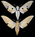 | 6,374 × 6,661 (12.82 MB) | Archaeodontosaurus | {{Information |Description ={{en|1=cb}} |Source ={{own}} |Author =Archaeodontosaurus |Date = |Permission = |other_versions = }} |
File usage
The following pages on the English Wikipedia use this file (pages on other projects are not listed):
Global file usage
The following other wikis use this file:
- Usage on ast.wikipedia.org
- Usage on es.wikipedia.org
- Usage on fr.wikipedia.org
- Usage on it.wikipedia.org
- Usage on nl.wikipedia.org
- Usage on no.wikipedia.org
- Usage on pt.wikipedia.org
- Usage on ro.wikipedia.org
- Usage on species.wikimedia.org
- Usage on sv.wikipedia.org
- Usage on vi.wikipedia.org
- Usage on war.wikipedia.org
- Usage on www.wikidata.org