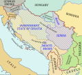
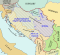
File:1941-1943 Axis occupation of Yugoslavia map - en.svg
Appearance

Size of this PNG preview of this SVG file: 657 × 599 pixels. Other resolutions: 263 × 240 pixels | 526 × 480 pixels | 842 × 768 pixels | 1,123 × 1,024 pixels | 2,246 × 2,048 pixels | 1,613 × 1,471 pixels.
Original file (SVG file, nominally 1,613 × 1,471 pixels, file size: 2.89 MB)
File history
Click on a date/time to view the file as it appeared at that time.
| Date/Time | Thumbnail | Dimensions | User | Comment | |
|---|---|---|---|---|---|
| current | 07:20, 17 February 2014 |  | 1,613 × 1,471 (2.89 MB) | Hellerick | Krk annexed by Italy. |
| 16:32, 12 February 2014 |  | 1,613 × 1,471 (2.9 MB) | Hellerick | oops, wrong language | |
| 02:36, 12 February 2014 |  | 1,613 × 1,471 (2.9 MB) | Hellerick | + maritime boundaries | |
| 04:19, 31 July 2013 |  | 1,613 × 1,471 (984 KB) | Hellerick | More contrast | |
| 05:29, 30 July 2013 |  | 1,613 × 1,471 (923 KB) | Hellerick | Part of Greece annexed by Italy. | |
| 04:50, 30 July 2013 |  | 1,613 × 1,471 (922 KB) | Hellerick | User created page with UploadWizard |
File usage
The following 3 pages use this file:
Global file usage
The following other wikis use this file:
- Usage on bg.wikipedia.org
- Usage on fa.wikipedia.org
- Usage on ka.wikipedia.org
- Usage on pl.wikipedia.org
- Usage on zh.wikipedia.org


