
File:1873 Beers Map of Richmond Hill, Queens, New York City - Geographicus - RichmondHill-beers-1873.jpg

Size of this preview: 356 × 600 pixels. Other resolutions: 142 × 240 pixels | 285 × 480 pixels | 456 × 768 pixels | 607 × 1,024 pixels | 1,215 × 2,048 pixels | 2,967 × 5,000 pixels.
Original file (2,967 × 5,000 pixels, file size: 3.44 MB, MIME type: image/jpeg)
| This is a file from the Wikimedia Commons. Information from its description page there is shown below. Commons is a freely licensed media file repository. You can help. |
| Richmond Hill. Laid out expressly for private Residences, and restricted against all nuisances. Property of A. P. Man. | ||||||
|---|---|---|---|---|---|---|
| Artist | ||||||
| Title |
Richmond Hill. Laid out expressly for private Residences, and restricted against all nuisances. Property of A. P. Man. |
|||||
| Description |
English: A scarce example of Fredrick W. Beers’ map of the town of Richmond, Queens, New York. Published in 1873. Covers roughly from Clarenceville north to Newtown Road. Detailed to the level of individual buildings and properties with land owners noted. Richmond Hill was the vision Albon P. Man, a successfully banker who bought the Lefferts and Welling farms in 1868. Albon envisioned an elegant planned community and the architect and landscape designer Edward Richmond to design it. Richmond Hill became one of the first planned residential communities in Long Island. This is probably the finest atlas map of the town of Richmond Hill, Queens, to appear in the 19th century. Prepared by Beers, Comstock & Cline out of their office at 36 Vesey Street, New York City, for inclusion in the first published atlas of Long Island, the 1873 issue of Atlas of Long Island, New York. |
|||||
| Date | 1873 (undated) | |||||
| Dimensions | height: 23.5 in (59.6 cm); width: 13.5 in (34.2 cm) | |||||
| Accession number |
Geographicus link: RichmondHill-beers-1873 |
|||||
| Source/Photographer |
Atlas of Long Island, New York. From Recent Actual Surveys and Records Under the Superintendence of F. W. Beers. (1873 First Edition).
|
|||||
| Permission (Reusing this file) |
|
|||||
| Other versions | File:Richmond Hill. NYPL1527298.tiff | |||||
| Object location | | View this and other nearby images on: OpenStreetMap |
|---|
File history
Click on a date/time to view the file as it appeared at that time.
| Date/Time | Thumbnail | Dimensions | User | Comment | |
|---|---|---|---|---|---|
| current | 18:54, 16 March 2011 | 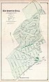 | 2,967 × 5,000 (3.44 MB) | BotMultichill | {{subst:User:Multichill/Geographicus |link=http://www.geographicus.com/P/AntiqueMap/RichmondHill-beers-1873 |product_name=1873 Beers Map of Richmond Hill, Queens, New York City |map_title=Richmond Hill. Laid out expressly for private Residences, and restr |
File usage
The following pages on the English Wikipedia use this file (pages on other projects are not listed):