
Falera
Falera | |
|---|---|
 | |
 Coat of arms | |
Location of Falera  | |
 Falera  Falera | |
| Coordinates: 46°48′N 9°13′E / 46.800°N 9.217°E | |
| Country | Switzerland |
| Canton | Graubünden |
| District | Surselva |
| Area | |
| • Total | 22.36 km2 (8.63 sq mi) |
| Elevation | 1,220 m (4,000 ft) |
| Population (31 December 2018)[2] | |
| • Total | 615 |
| • Density | 28/km2 (71/sq mi) |
| Time zone | UTC+01:00 (Central European Time) |
| • Summer (DST) | UTC+02:00 (Central European Summer Time) |
| Postal code(s) | 7153 |
| SFOS number | 3572 |
| ISO 3166 code | CH-GR |
| Surrounded by | Laax, Ladir, Ruschein, Sagogn, Schluein, Schnaus |
| Website | www SFSO statistics |
Falera is a municipality in the Surselva Region in the Swiss canton of Graubünden.
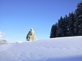
Falera is a part of the Alpenarena along with the towns of Flims and Laax and is the most secluded of the three.
History[edit]


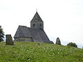
Falera is a town of rich culture and history. In 1800 B.C., a settlement was started on the Mutta. This came during the Bronze Age and was very significant in the early development of what today is Switzerland. The village is first mentioned in 765 as Falariae.[3] While the first actual mention of a church in Falera was in 840-841. However, the current church was not built until 1491. The church was built on the foot of the Mutta and was named after St. Remigius. Around the church are stone pillars (megaliths or menhirs), arranged geometrically, that are said to date around 1500 B.C.
Later, in the year 1903, another church was built. This church was built directly in the village and was named the Herz-Jesu-Kirche or "Heart of Jesus Church" . It, along with the original Falera church, are still standing today and the main attractions of Falera.
Falera today[edit]
Today, Falera is mostly overshadowed by the other two villages of the Alpenarena: Laax and Flims. Most people that have apartments in Falera do not live there year-round, but rather use them as vacation homes and weekend trips. The main language spoken is Romansh, a Romance language that is said to have descended from vulgar Latin.
The Sternwarte Mirasteilas, an astronomical observatory, was established by José De Queiroz in 2006.
Geography[edit]

Falera has an area, (as of the 2004/09 survey) of 22.36 km2 (8.63 sq mi).[4] Of this area, about 60.0% is used for agricultural purposes, while 20.0% is forested. Of the rest of the land, 2.6% is settled (buildings or roads) and 17.3% is unproductive land. In the 2004/09 survey a total of 37 ha (91 acres) or about 1.7% of the total area was covered with buildings, an increase of 12 ha (30 acres) over the 1984/85 amount. Of the agricultural land, 394 ha (970 acres) is fields and grasslands and 1,035 ha (2,560 acres) consists of alpine grazing areas. Since 1984/85 the amount of agricultural land has decreased by 100 ha (250 acres). Over the same time period the amount of forested land has increased by 40 ha (99 acres). Rivers and lakes cover 17 ha (42 acres) in the municipality.[5][6]
Before 2017, the municipality was located in the Ilanz sub-district of the Surselva district, after 2017 it became part of the Surselva Region.[7] It is located on a terrace above the left bank of the Vorderrhein river at an elevation of 1,218 m (3,996 ft). Until 1969 Falera was known as Fellers.[8]
Demographics[edit]
Falera has a population (as of December 2020[update]) of 625.[9] As of 2017[update], 13.6% of the population are resident foreign nationals. In 2015 a small minority (63 or 10.3% of the population) was born in Portugal.[10] Over the last 7 years (2010-2017) the population has changed at a rate of 7.60%. The birth rate in the municipality, in 2017, was 11.4, while the death rate was 3.2 per thousand residents.[6]
As of 2017[update], children and teenagers (0–19 years old) make up 18.5% of the population, while adults (20–64 years old) are 54.7% of the population and seniors (over 64 years old) make up 26.8%.[6] In 2015 there were 244 single residents, 326 people who were married or in a civil partnership, 18 widows or widowers and 26 divorced residents.[11]
In 2017 there were 268 private households in Falera with an average household size of 2.32 persons. In 2015 about 23.7% of all buildings in the municipality were single family homes, which is much less than the percentage in the canton (49.4%) and much less than the percentage nationally (57.4%).[12] Of the 321 inhabited buildings in the municipality, in 2000, about 30.5% were single family homes and 59.8% were multiple family buildings. Additionally, about 17.1% of the buildings were built before 1919, while 17.8% were built between 1991 and 2000.[13] In 2016 the rate of construction of new housing units per 1000 residents was 11.4. The vacancy rate for the municipality, in 2018[update], was 1.04%.[6]
The historical population is given in the following chart:[14]

Economy[edit]
Falera is classed as a semitourist community.[15]
As of 2016[update], there were a total of 173 people employed in the municipality. Of these, a total of 31 people worked in 11 businesses in the primary economic sector. The secondary sector employed 64 workers, of which 54 people worked for one business. Finally, the tertiary sector provided 78 jobs in 22 businesses.[16]
In 2017 a total of 11.4% of the population received social assistance.[6] In 2011 the unemployment rate in the municipality was 1.3%.[17]
In 2015 the average cantonal, municipal and church tax rate in the municipality for a couple with two children making SFr 80,000 was 3.2% while the rate for a single person making SFr 150,000 was 13.8%. The canton has an average tax rate for those making SFr 80,000 and an average rate for those making SFr 150,000. In 2013 the average income in the municipality per tax payer was SFr 54,054 and the per person average was SFr 36,855, which is less than the cantonal average of SFr 69,964 but greater than the per person amount of SFr 33,075. It is also less than the national per tax payer average of SFr 82,682 but greater than the per person average of SFr 35,825.[18]
Politics[edit]
In the 2019 federal election the most popular party was the CVP with 45.4% of the vote. The next three most popular parties were the SVP (29.3%), the GLP (7.8%) and the FDP (7.2%). In the federal election, a total of 260 votes were cast, and the voter turnout was 57.3%.[19]
Languages[edit]
Most of the population (as of 2000[update]) speaks Romansh (67.5%), with German being second most common (28.8%) and Italian being third (2.0%).[20] Until the late 20th Century, the entire population spoke the Romansh dialect of Surselvisch. In 1880 about 99% spoke Romansh as a first language, while in 1941 it was 97% and in 2000 it had decreased to 67%. In 1990 about 90% of the population understood Romansh and in 2000 it was 78%.
| Languages in Falera | ||||||
| Languages | Census 1980 | Census 1990 | Census 2000 | |||
| Number | Percent | Number | Percent | Number | Percent | |
| German | 42 | 10.97% | 71 | 17.57% | 145 | 28.77% |
| Romansh | 309 | 80.68% | 327 | 80.94% | 340 | 67.46% |
| Italian | 7 | 1.83% | 3 | 0.74% | 10 | 1.98% |
| Population | 383 | 100% | 404 | 100% | 504 | 100% |
End of 2013, 381 persons, 64.4% are of Romansh mother tongue, 145 persons, 24.5% are of German mother tongue and 66 persons, 11.1% indicate other languages as mother tongue.
Religion[edit]
From the 2000 census[update] 84% are Roman Catholic, while 10% belonged to the Swiss Reformed Church and 1% that are Orthodox. About 0.6% did not answer the question.[21]
Heritage sites of national significance[edit]
The Church of S. Rumetg/St. Remigius and the Muota/Mutta and Planezzas (prehistoric settlements and megalith sites) are listed as Swiss heritage sites of national significance.[22]
- Church St. Remigius and Menhirs near Falera
-
 St. Remigius
 -
 Menhir
 -
 Menhirs near St. Remigius
 -
 The Mutta and St. Remigius
 -
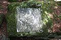 Petroglyph from the megalith site
 -
 Menhir or standing stone (Megalith) with the Church of San Remigius
 -
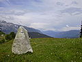 Standing stone near Falera


References[edit]
- ^ a b "Arealstatistik Standard - Gemeinden nach 4 Hauptbereichen". Federal Statistical Office. Retrieved 13 January 2019.
- ^ "Ständige Wohnbevölkerung nach Staatsangehörigkeitskategorie Geschlecht und Gemeinde; Provisorische Jahresergebnisse; 2018". Federal Statistical Office. 9 April 2019. Retrieved 11 April 2019.
- ^ Falera in German, French and Italian in the online Historical Dictionary of Switzerland.
- ^ Arealstatistik Standard - Gemeindedaten nach 4 Hauptbereichen
- ^ "Arealstatistik Land Use - Gemeinden nach 10 Klassen". www.landuse-stat.admin.ch. Swiss Federal Statistical Office. 24 November 2016. Retrieved 14 February 2018.
- ^ a b c d e "Regional portraits 2019: key data of all communes". bfs.admin.ch. Swiss Federal Statistical Office. 28 March 2019. Retrieved 14 October 2019.
- ^ Swiss Federal Statistical Office - Amtliches Gemeindeverzeichnis der Schweiz - Mutationsmeldungen 2016 accessed 16 February 2017
- ^ Amtliches Gemeindeverzeichnis der Schweiz published by the Swiss Federal Statistical Office (in German) accessed 23 September 2009
- ^ "Ständige und nichtständige Wohnbevölkerung nach institutionellen Gliederungen, Geburtsort und Staatsangehörigkeit". bfs.admin.ch (in German). Swiss Federal Statistical Office - STAT-TAB. 31 December 2020. Retrieved 21 September 2021.
- ^ Federal Statistical Office - Ständige und nichtständige Wohnbevölkerung nach institutionellen Gliederungen, Geburtsort und Staatsangehörigkeit (Land) accessed 31 October 2016
- ^ Swiss Federal Statistical Office - Ständige und nichtständige Wohnbevölkerung nach institutionellen Gliederungen, Geschlecht, Zivilstand und Geburtsort (in German) accessed 8 September 2016
- ^ Statistical Atlas of Switzerland - Anteil Einfamilienhäuser am gesamten Gebäudebestand, 2015 accessed 18 May 2017
- ^ Swiss Federal Statistical Office STAT-TAB - Thema 09 - Bau- und Wohnungswesen (in German) accessed 5 May 2016
- ^ Swiss Federal Statistical Office STAT-TAB Bevölkerungsentwicklung nach institutionellen Gliederungen, 1850-2000 (in German) accessed 27 April 2016
- ^ "Gemeindetypologie 2000 (22 und 9 Typen)". www.bfs.admin.ch/bfs/de/home/statistiken/querschnittsthemen/raeumliche-analysen/raeumliche-gliederungen/analyseregionen.html (in German, French, Italian, and English). Neuchâtel, Switzerland: Swiss Federal Statistical Office. 17 February 2016. Retrieved 14 December 2016.
- ^ Swiss Federal Statistical Office -Arbeitsstätten und Beschäftigte nach Gemeinde, Wirtschaftssektor und Grössenklasse accessed 26 June 2019
- ^ "Arbeitslosenquote 2011". Statistical Atlas of Switzerland. Swiss Federal Statistical Office. Retrieved 4 May 2017.
- ^ "18 - Öffentliche Finanzen > Steuern". Swiss Atlas. Swiss Federal Statistical Office. Retrieved 26 April 2017.
- ^ "Eidgenössische Wahlen 2019". opendate.swiss. Swiss Federal Statistical Office. 20 October 2019. Retrieved 12 November 2019.
- ^ Swiss Federal Statistical Office accessed 4 October 2011
- ^ "STAT-TAB". www.pxweb.bfs.admin.ch/. Swiss Federal Statistical Office. 2000. Retrieved 31 October 2019.
- ^ "Swiss inventory of cultural property of national and regional significance". A-Objects. Federal Office for Cultural Protection (BABS). 1 January 2017. Archived from the original on 2 September 2016. Retrieved 6 September 2017.
External links[edit]
Municipalities in the Surselva Region, Switzerland | ||
|---|---|---|
| International | |
|---|---|
| National | |
| Other | |