Befandriana-Nord District
Appearance
Befandriana-Nord District
Befandriana-Avaratra | |
|---|---|
District | |
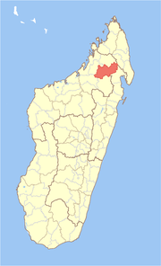
 Location in Madagascar | |
| Coordinates: 15°9′S 48°48′E / 15.150°S 48.800°E | |
| Country | |
| Region | Sofia |
| Area | |
• Total | 8,718.98 km2 (3,366.42 sq mi) |
| Population (2020) | |
• Total | 271,314 |
| • Density | 31/km2 (81/sq mi) |
| • Ethnicities | Tsimihety |
| Time zone | UTC3 (EAT) |
| Postal code | 409 |

Befandriana-Nord or Befandriana-Avaratra (literally North Befandriana) is a district in northern Madagascar. It is a part of Sofia Region and borders the districts of Bealanana in north, Andapa to the northeast, Maroantsetra to the east, Mandritsara to the south, Boriziny-Vaovao (formerly Port-Bergé) to the southwest and Antsohihy to the north-west. The area is 8,718.98 km2 (3,366 sq mi) and the population was estimated to be 271,314 in 2020.[1][2]
Communes
[edit]The district is further divided into 12 communes:
- Ambararata
- Ambodimotso-Atsimo
- Ambolidibe Atsinanana
- Ankarongana
- Antsakabary
- Antsakanalabe
- Befandriana-Avaratra
- Maroamalona
- Matsondana
- Morafeno
- Tsarahonenana
- Tsiamalao
Transport
[edit]The district is crossed by the Route nationale 32.
Nature
[edit]- Part of Makira Natural Park
References and notes
[edit]- ^ "Madagascar: Administrative Division (Regions and Districts) - Population Statistics, Charts and Map". www.citypopulation.de. Retrieved 2024-01-17.
- ^ Institut National de la Statistique, Antananarivo.

