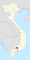
An Thạnh, Bình Dương
Appearance
You can help expand this article with text translated from the corresponding article in Vietnamese. (March 2015) Click [show] for important translation instructions.
|
An Thạnh
Phường An Thạnh Búng | |
|---|---|
 Location of An Thạnh in Bình Dương province | |
| Coordinates: 10°56′44.8″N 106°41′23.6″E / 10.945778°N 106.689889°E | |
| Country | |
| Region | Southeast |
| Province | Bình Dương |
| City | Thuận An |
| Area | |
| • Total | 2.9 sq mi (7.5 km2) |
| Population (2011)[1] | |
| • Total | 25,178 |
| • Density | 8,690/sq mi (3,357/km2) |
| Time zone | UTC+7 (Indochina Time) |
| Postal code | 75212 |
| Area code | 274 |
An Thạnh is a ward of Thuận An city in Bình Dương Province of Southeast region of Vietnam.
Along with the name An Thạnh, Búng is also a common name of this area. The central market here is also named as Búng market.
Since Minh Mạng dynasty, An Thạnh and Tân Thới (Lái Thiêu nowadays) have been the two downtown and commercial centre of former Lái Thiêu district; however, the county seat was in Tân Thới until now. After 1975, Lái Thiêu district renamed to Thuận An district, An Thạnh became the district's commune then town. Until 2011, when Thuận An was upgraded to district-level town, An Thạnh town also became the ward of this town and now is ward of Thuận An city.

