
Centerville, Tyler County, West Virginia
Centerville, West Virginia | |
|---|---|
 Centerville, West Virginia  Centerville, West Virginia | |
| Coordinates: 39°25′55″N 80°50′24″W / 39.43194°N 80.84000°W | |
| Country | United States |
| State | West Virginia |
| County | Tyler |
| Elevation | 764 ft (233 m) |
| Time zone | UTC-5 (Eastern (EST)) |
| • Summer (DST) | UTC-4 (EDT) |
| ZIP code | 26320 |
| Area code(s) | 304 & 681 |
| GNIS feature ID | 1554098[1] |
Centerville (Formerly Ripley Mills[2]) — also known as Alma — is an unincorporated community in Tyler County, West Virginia, United States. Centerville is located along West Virginia Route 18, 5.4 miles (8.7 km) southeast of Middlebourne.[3] Centerville has a post office with ZIP code 26320; the post office uses the name Alma.[4][5]
History[edit]
The Centerville/Alma area is where three streams (McElroy Creek, Wheeler Run and Conaway Run) flow into Middle Island Creek within a short distance of one another. The earliest white settler was John McElroy who gave his name to McElroy Creek and was killed by Indians there. This was likely in the early 1790s, as the natives had effectively been expelled by 1795. William Underwood (1780-1866) and his family settled there on 23 March 1812. He had been appointed constable of the McElroy District and was granted 2000 acres of land on McElroy. He was also appointed Captain of the Virginia militia in the same year. He served as Justice of the Peace there for 37 years. In April 1840, "Squire" Underwood hosted John Brown (1800-59) — later the famous abolitionist and terrorist — who was in the area scouting land and properties.
References[edit]
- ^ "Centerville". Geographic Names Information System. United States Geological Survey, United States Department of the Interior.
- ^ "John Brown and the Oberlin Lands", by Boyd B. Stutler; "West Virginia History"; Vol. 12, No. 3 (Apr 1951), pp. 183-99.
- ^ Tyler County, West Virginia General Highway Map (PDF) (Map). West Virginia Department of Transportation. 2011. p. 1. Archived from the original (PDF) on April 25, 2012. Retrieved January 3, 2012.
- ^ United States Postal Service (2012). "USPS - Look Up a ZIP Code". Retrieved February 15, 2012.
- ^ "Postmaster Finder - Post Offices by ZIP Code". United States Postal Service. Archived from the original on October 17, 2020. Retrieved January 3, 2012.
Municipalities and communities of Tyler County, West Virginia, United States | ||
|---|---|---|
| Cities | 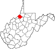 | |
| Towns | ||
| Unincorporated communities | ||
| Footnotes | ‡This populated place also has portions in an adjacent county or counties | |
This article about a location in Tyler County, West Virginia is a stub. You can help Wikipedia by expanding it. |